


Interactive Maps
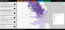
Explore interactive data maps for the City of Milwaukee designed to bring key information to community members, planners, policy makers, and neighborhood organizations across the city.
Neighborhood Dashboard
Hosting a community conversation about a topic or issue that concerns your neighborhood or community is even more powerful when supported by data and personal stories. Learn more about our Guide to Data Chats here.
Data Chats
Explore interactive data maps for the City of Milwaukee designed to bring key information to community members, planners, policy makers, and neighborhood organizations across the city.
Data Day
Join us on October 15, 2025 for our annual event, centered around the people and organizations who are using data to improve their neighborhoods and communities in Milwaukee and beyond.
Want to Support Data You Can Use?
Make a donation and support our efforts to make community data more accessible for all.
Our Latest Highlights
No Results Found
The page you requested could not be found. Try refining your search, or use the navigation above to locate the post.
Data You Can Use is proud to serve as Milwaukee’s representative to the Urban Institute’s National Neighborhood Indicators Partnership. As a partner, we work to democratize data by building local capacity, sharing best practices, and helping users sort through the data to surface, explain, and address issues of concern.